Frequently Asked Questions
Details on all facets of the project, from its economic benefits, water management, utilities, and more.
Use the buttons below to quickly navigate to each section.
Project Overview
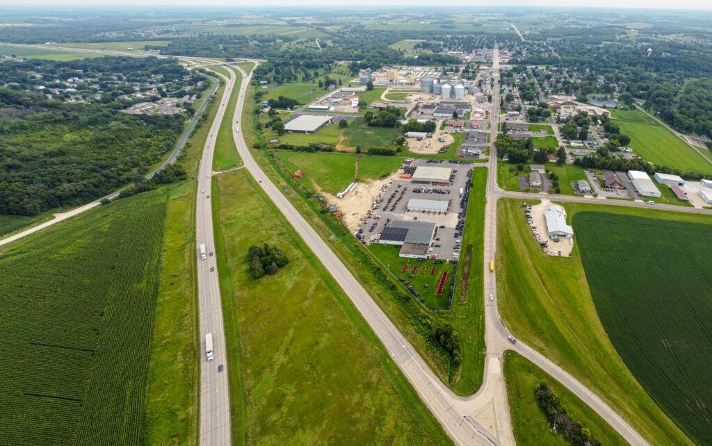
Why Pine Island?
Ryan Companies is evaluating this site because Pine Island offers what growing industries need: ready-to-develop land, reliable utilities, and a community that has already designated this area for future industrial use in its Comprehensive Plan. Pine Island provides space, stability, and long-term potential that larger cities around it simply can’t. That combination makes this small town a strong candidate for meaningful investment.
What is the status of the project?
Ryan has been working proactively with the City of Pine Island and other project partners to prepare over 400 acres for future development, including completing the AUAR process, hosting three public open houses, and participating in multiple public meetings. These meetings began in March 2025, when the City Council started reviewing the AUAR through a series of sessions, leading up to its official adoption and submission. Several companies have evaluated—and will continue to evaluate—the site for potential investment. As is common practice in site selection, these evaluations remain confidential to protect business interests in a highly competitive environment. The initial project entitlements received unanimous approval at the January city council meeting, and permit submissions are anticipated in early 2026. Through the remainder of the project, we will continue to update the project website accordingly.
What is an AUAR?
The Alternative Urban Areawide Review (AUAR) is a well-established planning tool in Minnesota for responsibly planning multi-phase, market-driven projects. Since 1988, it has been used to analyze large areas of land that may be subject to various uses over time. Given the size and anticipated duration of the Pine Island development, the AUAR provides a framework to responsibly react to market interest.
Who is leading the development, and who will ultimately operate the project?
Ryan Companies is guiding the planning, approvals, and overall development of the site. Google has been announced as the tenant for the first data center and office building. Ryan Companies and Google are also evaluating additional portions of the site.
Which local and state government agencies and utilities will be involved in reviewing the project?
- Minnesota Pollution Control Agency (MPCA)
- Minnesota Department of Transportation (MNDOT)
- Minnesota Department of Natural Resources (DNR)
- Minnesota State Historic Preservation Office (SHPO)
- Minnesota Public Utilities Commission
- City of Pine Island
- Pine Island Township
- Goodhue County
- Xcel Energy
Building Height, Buffer & SetBACK
What are the height limits for buildings in this development?
The PUD sets a maximum building height of 60 feet, with the option to increase up to 80 feet through a Conditional Use Permit. Any building taller than 45 feet must also meet an increased setback beyond the standard code requirement. The first proposed buildings are well below these limits: the primary building is planned at 38 feet, and the associated office building at 15 feet.
What are the required setbacks and planned perimeter buffing?
The first proposed project goes beyond the I-2 zoning requirement with a setback of at least 80 feet from the Highway 52 right-of-way, 50% beyond the standard. Hundreds of trees will be planted along the perimeter of the site for additional buffering.
Community Benefits & Economics
How does this development impact the city financially?
The project would have a hugely positive impact on the City. It’s expected to generate tens of millions of dollars in new property tax revenue for the City, Goodhue County, and the Pine Island School District. This project would add significant taxable values to these jurisdictions without the need for substantial municipal services, thus adding revenue with minimal additional cost. The developer is also paying for more than $20M in public infrastructure upgrades, something cities usually cover themselves. The City is working with the County and financial advisors on tax models related to the potential project.
How will the project affect city tax revenue?
The project is expected to bring tens of millions in additional tax revenue to the City, County, and School District, supporting existing and expanded public services.
Power & Utilities
Will my utilities increase?
In short, no. Utility bill increases typically occur when utility companies invest in their infrastructure and service delivery, and the cost is spread across all users, rather than due to a single development project. To protect against this possibility, Xcel Energy files with the Public Utilities Commission to establish consumer safeguards. Infrastructure upgrades for large customers are paid for by the developer to prevent this cost-sharing. Like nearly every other service, utility bills (including electricity) can increase over time, but won’t as a direct result of this project. Locally managed utilities, such as water, sewer, and storm sewer charges, will not increase as a result of this project.
What are the sustainable energy goals?
Xcel Energy will serve the project and will meet the State of Minnesota requirement to be carbon-free by 2040.
Water & Environment
What is the proposed water usage?
Water will be used for standard office purposes, including bathrooms, showers, and on-site food services. The estimated water usage amount for the initial phase is anticipated to be less than 15% of the total 152,000 gallons per day for the overall development (according to the adopted AUAR), which is less than that of a similarly sized residential subdivision.
For comparison:
- Approximately 450 acres of irrigated cropland would require around 400,000 gallons of water per day.
- The same project area (over 400 acres) would support over 1,000 homes and would use about 274,000 gallons per day.
How will green space, landscaping, and natural features be incorporated into the project?
The development will include significantly more green space than the City requires—increasing the minimum from 25% to 35%, with the first project featuring about 65% green space on its own.
- Early phases will plant more than 300 new trees and establish 41 acres of native grasses and pollinator-friendly plants that are designed to thrive without irrigation once established, creating a natural, low-maintenance landscape.
- Stormwater management will be integrated into these green areas to support filtration, protect water quality, and maintain a healthy, natural environment throughout the site.
What are other environmental and sustainability considerations?
The project will meet, or exceed, all state and local permitting requirements.
Lighting & Noise
How will lighting be managed around the site?
The project will utilize LED cutoff fixtures to minimize glare and limit light spillage, with lighting capped at 0.5 foot-candles at the property line. This proposed PUD standard is stricter and more clearly defined than the City’s current lighting requirements.
How will the project meet state noise standards?
The project will comply with Minnesota’s State Noise Standards for residential areas, which allow up to 60 dBA during the day and 50 dBA at night. For context, the current noise level about 2,300 feet from Highway 52 is roughly 50 dBA, which is similar to a quiet refrigerator, a library, or a normal conversation.
Traffic & Infrastructure
How will traffic be addressed as part of this project?
The Traffic Study in the AUAR evaluated two potential traffic generation scenarios. For the higher trip generation scenario, the suggested improvements include:
- Paving White Pines Road up to 500th Street
- Adding a sidewalk along the east side of White Pines Road
- Adding a bypass lane on westbound County Road 11 at the southbound on-ramp to Highway 52
What infrastructure, buffers, and design standards will guide development on the site?
Ryan Companies will invest $20M+ in major public infrastructure, including 2.5 miles of new water main, a half-mile of sewer, and upgrading nearly a mile of gravel road to a paved city street.
The PUD meets all I-2 zoning rules, with the first phase providing an 80-foot Highway 52 setback—about 50% more than required. The nearest neighborhood is over 4,250 feet away from the initial phase. The PUD also sets clear standards for durable, high-quality building materials to ensure a consistent, attractive look as the area develops.
How will parking be designed for the site?
Parking will be sized to match the project’s largest employee shift, ensuring there is adequate parking without creating large, unused paved areas. This approach reduces unnecessary impervious surface and supports better overall stormwater management.
Additional Resources
Where can I find official information from the City of Pine Island?
Where can I review the AUAR and related environmental documents?
How has local media covered key milestones in this project?
- 3/4/2025: Pine Island City Council Starts Environmental Process Toward 482 Acre Industrial Park
- 5/31/2025: Development Booming For Rochester’s Neighbors
- 9/16/2025: Pine Island Council Meeting Draws Data Center Opponents
- 10/8/2025: Pine Island Town Hall Brings Residents with Questions on Project Skyway
- 10/17/2025: Environmental Group Appeals Against Pine Island Technology Park
- 11/11/2025: What’s the Real Story with Data Center Developments?
- 12/16/2025: Pine Island City Council Approves Preliminary Plat and Development Plan for Data Center Technology Park
- 2/5/2026: Pine Island Council Hears Then Approves Financial Incentive Plan for Project Skyway
- 2/24/2026: The Company Building Pine Island Data Center is Finally Revealed
- 2/25/2026: Google News Does Little to Ease Concerns of Pine Island Data Center Opponents
- 3/28/2026: Flurry of Filings Come as Court Dates Draw Near for Pine Island Data Center
Where can I find a quick fact sheet about the project?
How can I learn more about electricity planning, rates, and regulations that relate to large developments?
Stay informed about the project
Sign up to stay informed on the latest project news, planning updates, and developments.